
In my last post I talked about getting a good physical size of nation and the world. The next step is actually populating the sucker. Otherwise known as Fun With Spreadsheets.
Traditional D&D has used a “points of lights” approach to the setting, with individual cities and towns being beacons of civilization surrounded by savage, magical wilderness. Even thought my homebrew started as a D&D4e pastiche, I wanted a different feel. My inspiration for this nation was more iron-age Celt than generic medieval fantasy, and their magical technology would be dominated by druids and other nature magic sorts, so there would be a lot of ecosystem management and living close to the land. In my mind, that means most people would live smaller villages and hamlets — too small to have things like taverns and inns and mayors and thieves guilds. Even the bigger cities would still be fairly modest.
So, okay, that gives me a vague goal to shoot for. But I needed a list and location of all the towns over about 1,000 people, and another of all the cities of over 8,000 people because I had put in the rules that characters could buy certain magic items only in towns and cities. So I imagined they’d want to be able to look at the map of the nation and say “Okay, we have gold to spend and need to equip ourselves before heading into the swamp, what’s a route that will let us swing by a decent marketplace?” Plus, I just wanted to know what all the cities and towns were.
I used medieval Europe population distribution as a touchstone, mostly because that’s about the technology level I was looking at and because Europe has easy resources to find about it. So, with my vision of the world firmly in mind, it was time to get down to the nitty gritty of populating the world.
I started by referring to Medieval Demographics Made Easy. By the way, I recommend reading the whole article and bookmarking it if you’re a world builder, but one key take away is that the density for well-developed medieval kingdom is anywhere from 30 to 120 people/sq mile. I decided that since the Weald was dominated by primal magic users, it would be magically fertile, but the culture would lean towards rural life and healthy ecosystems. So I chose about a population density of about 70 people/sq mile, which, given a land area of 90,000, means there are about 2.7 million people in the Weald.
Since they’re a relatively non-urban society, I chose 90% to living rurally, scattered among villages, hamlets, forts, and camps, which means the remaining 10% to live in cities and towns of over 1,000 people.
Cities and Towns
I started by imagining the biggest city I wanted to have in the Weald. Since I was taking some cues from iron-age to medieval British Isles, I looked at London as a rough guide, which had a population between 25,000 to 40,000 people. I chose my capital to be comparably sized, at about 30,000.
That excellent article recommends that cities and towns be 20%-80% of the next biggest city. So, try it – create a spreadsheet. Start with a population of 1,000, and then created a column where each subsequent row = previous row/.8
And then have an equation that looks like = SUM(First Row: Last Row)
The problem is that even with a ratio of .8, in order for the sum of the cities and towns populations to be 270,000 (10% of the population), you’d need a capital city of about 55,000, which is larger than I wanted to have.
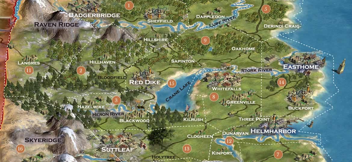
I debated whether I wanted to make the country less than 10% urban, but decided instead to increase the ratio between town to next biggest town to about .9 . That gave me 27 cities and towns to flesh out — 17 towns, 5 smaller cities and 5 bigger cities, with the largest being the capital of 32,000. A bit more than I was hoping for, but doable. Heres’s a copy of my spreadsheet (note, I decided on the names after I figured out the geography in the next post).
| Pop. | Name | Total Pop. |
|---|---|---|
| 1,100 | Kinport | 1,100 |
| 1,200 | Clogheen | 2,300 |
| 1,400 | Gillistrand | 3,700 |
| 1,800 | Three Point | 5,500 |
| 1,850 | Oakhome | 7,350 |
| 2,300 | Dunarven | 9,650 |
| 2,300 | Caermorgan | 11,950 |
| 3,000 | Noren Dale | 14,950 |
| 3,400 | Sapinton | 18,350 |
| 3,500 | Langres | 21,850 |
| 4,200 | Falinlees | 26,050 |
| 4,300 | Seacliff | 30,350 |
| 4,900 | Hazelwike | 35,250 |
| 5,400 | Boundary Bay | 40,650 |
| 6,100 | Hillshire | 46,750 |
| 6,800 | Ruvenran | 53,600 |
| 7,800 | Kilrush | 61,400 |
| 8,400 | Suttleaf | 69,800 |
| 9,600 | Sheffield | 79,400 |
| 10,000 | Buckport | 89,400 |
| 11,950 | Dappledon | 101,350 |
| 13,800 | Blackwood | 115,150 |
| 14,800 | Greenville | 129,950 |
| 17,300 | Badgerbridge | 147,250 |
| 19,600 | Helmharbor | 166,850 |
| 22,000 | Whitefalls | 188,850 |
| 25,000 | Red Dike | 213,850 |
| 27,900 | Rosehall | 241,750 |
| 31,000 | Easthome | 272,750 |
The countryside
If 90% of the Weald lives in these small settlements, that’s 2.43 million people living in the countryside, outside the towns and cities. So my next questions was what does the countryside look like and how much of it is untamed wilderness?
To figure that out, I had to start with looking at the density again. The Weald’s total land area was 90,000 sq miles. Cities have maybe 30,000 people per sq mile, so there are about 9 urban sq miles in our little country. That leaves about 81,000 sq miles of non-urban countryside. Some of this is going to be true wilderness, some are going to be in fairly isolated hamlets and camps and homesteads, and some are going to form well-connected agrarian villages. But what proportion of each? To get a handle on it, I created another spreadsheet with a few assumptions.
First, I assumed true wilderness areas have an average settlement size of 10 people and had about 1 settlement per 100 sq miles (i.e. they’re about 10 miles apart from each other on average). That’s to account for natures preserves or areas in the mountain or subarctic circle that simply aren’t fertile enough to support that many people. There may still be hunting camps or sentry outposts or hermits or seasonal trappers or really antisocial loners or loving couples looking to challenge themselves by climbing mountains together or whatever. I’m a city girl, I don’t know.
Then I estimated that isolated settlements would have an average population of 30 people and a typical density of one every 10 square miles. That basically describing a couple families banding together in a homestead miles from the next closest homestead, where going to market is something that you have to plan out and would take a day or more in travel time.
And lastly, I estimated well-connected villages would average more like 200 people and have a density of 1 – they would be one every mile or so. That’s for a typical village where you actually have a village square and maybe a manor house for the equivalent of a country squire and where outlying farmers and loggers and trappers and what not come into town to trade.
To play with the numbers, I created a spreadsheet (surprise!). The first row is just breaking up the columns into three categories of countryside. The second row (yellow) is the row I actively changed – it’s the proportion of the countryside that was each type. I started with 1/3, 1/3, 1/3 and moved the numbers up and down until the total population became about 2.43 million. The sum of the second row numbers has to equal 1. The third row is land area. It’s a calculated row that shows total land area of that type by multiplying the proportion of land area x 81,000. The fourth and fifth row give population information for each category of rural countryside. The sixth row as the total population on the left (bold) and the total population of each type.
| Wilderness | Isolated | Connected | |
| Proportion of land | 0.25 | 0.61 | 0.14 |
| Land area | 20,250 | 49,410 | 11,340 |
| Average settlement population | 10 | 30 | 200 |
| Settlement density per sq mile | 0.01 | 0.1 | 1 |
| 2,418,255 | 2,025 | 148,230 | 2,268,000 |
So, what does that tell me? It says that we’re looking at A LOT empty land. Those cities and towns may have some richly settled farmland immediately around them, but about more than 3/4 of the land is either sparsely populated homesteads or untamed wilderness.
This is some empty, empty land.
On the other hand, most of the people live in the well-connected villages. If you add the well-connected village population with the town and city population, that’s 94% of the population living in settled areas. Places where they’re no more than a mile from the next settlement. They’re not city folk, but they’re not isolated either. I imagine this is a fairly communal, egalitarian country, but also one where there’s an expectation of law and stable societal institutions.
So, now we have a pretty good idea of what’s in the Weald. Next I’ll week walk through geography – figuring out where to put all those settlements and geographic features.

[…] Elegant and Fine is from the point of view of Susan from the Chronicles of Narnia, and completely changed my perception of her. […]
I’ve been thinking of dipping my toe into world building and these articles have given me a lot to think about. Looking forward to the next article.